
NEWS
Nepal Flood Leaves Hydropower Grid and Border Route Crippled
Day-four rescues stall in poor weather after the glacier collapse, while hundreds of hydropower workers stay missing and the Gyirong trade gateway lies destroyed.

Poor weather grounded Nepal Army helicopters on Saturday as the search for survivors of Wednesday’s ice-rock avalanche and flash floods entered its fourth day along the Nepal-China border. Police put the Nepali death toll at 616; Chinese state media had confirmed seven more, for a combined total of at least 623 dead and more than 2,400 still missing.
More than 3,700 people have already been pulled to safety. The immediate human cost continues to climb, yet the deeper damage sits in the hydropower tunnels and the single border corridor that once carried trade and pilgrims.
Each new tally redraws the same map: tunnels still packed with mud, a border gateway erased, and northern valleys without power while the capital’s lights stay on.
What the Glacier Collapse Did
At 8:37 a.m. local time on 26 August a mass of ice and rock sheared from a glacier near Langtang Lirung. The collapse registered as a magnitude 5.2 seismic event. The material fell more than 1,200 metres into the Lhende Khola, melted on impact, dammed the channel and then burst downstream as a debris-laden surge.
Water levels on the Trishuli rose as much as nine metres in half an hour. The wave scoured the Gyirong Port border complex on the Chinese side, destroyed bridges and roads for tens of kilometres, and carried bodies as far as 240 km downstream into India. Surveillance cameras caught the wall of mud and water hitting the checkpoint seven minutes after the seismic signal.
The sequence left little room for reaction. Rock and ice struck, melted, blocked the channel, then failed as a single pulse. Steep valley walls kept that pulse tight and fast all the way to the border and beyond.
Scientists who examined Planet Labs imagery and long-period seismic waves described a rock avalanche that took part of the glacier with it. One researcher compared the volume to 1,000 Empire State Buildings dropping into the valley at once. Climate warming that weakens permafrost is under discussion as a background factor; the proximate trigger remains the failure of the rock face that held the ice.
- Fall distance into the Lhende Khola: more than 1,200 metres.
- Trishuli rise: as much as nine metres in roughly thirty minutes.
- Checkpoint impact: seven minutes after the seismic signal.
- Downstream reach: bodies carried as far as 240 km into India.
Hydropower Workers and the Megawatts Now Offline
Thirteen hydropower projects took the direct hit. The Independent Power Producers’ Association of Nepal initially listed 933 workers as uncontactable. By late Friday more than 650 remained unaccounted for. At the Upper Trishuli-1 site alone, a 216 MW run-of-river plant still under construction, about 1,350 people had been working when the flood arrived; 576 stayed missing.
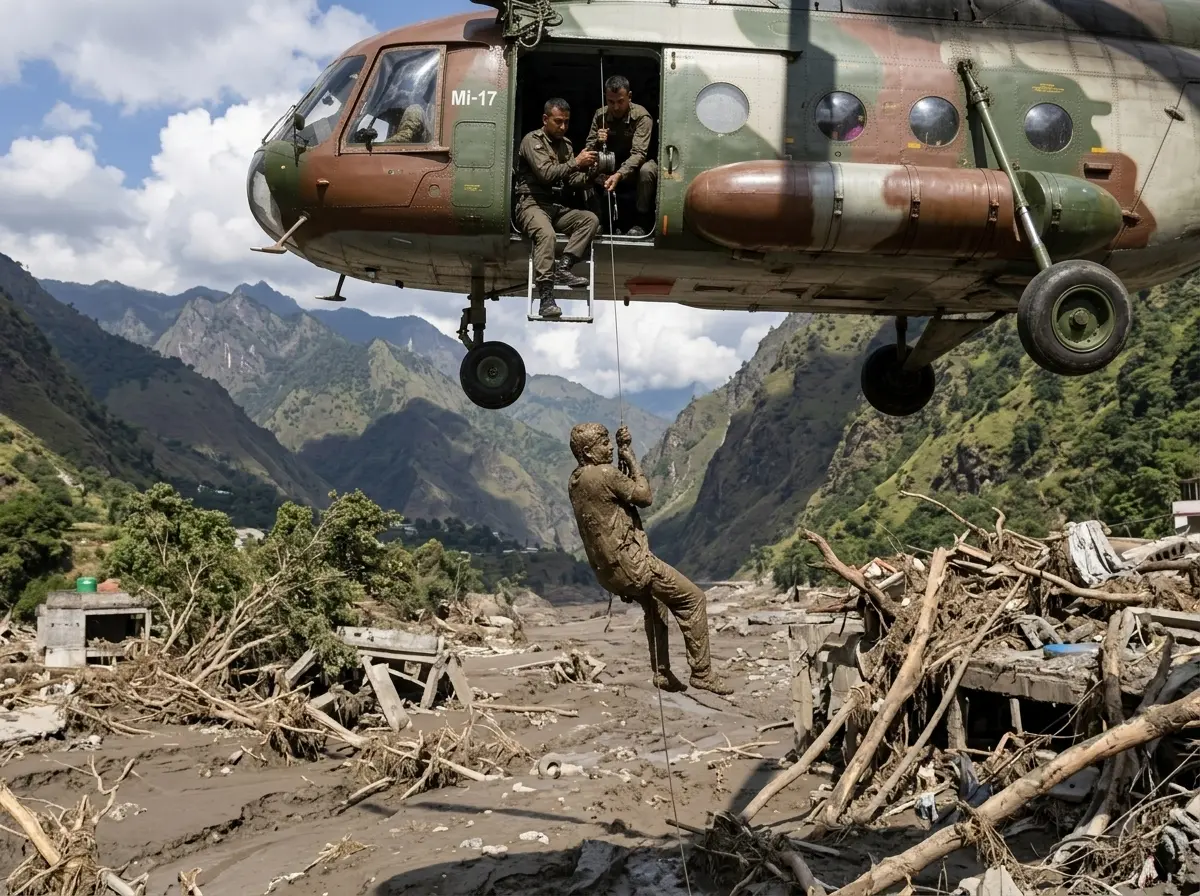
Nepali Army teams rescued roughly 350 people from one tunnel complex earlier in the week. On Saturday Brig. Gen. Raja Ram Basnet said more than 100 were still believed trapped behind four to five feet of thick mud. Rescuers used baskets and ropes where helicopters could not land. India prepared a specialised tunnel rescue team after Nepal requested technical help.
| Project or Cluster | Capacity Note | Workers Status |
|---|---|---|
| Upper Trishuli-1 | 216 MW under construction | 576 unaccounted of ~1,350 |
| Rasuwagadhi, Chilime, Trishuli 3A/3B | Major operating and hub facilities | Multiple sites among the 13 hit |
| Overall operating plants | ~431 MW offline | Part of 12-plus percent of national hydro |
| Projects under construction | ~470 MW damaged | Included in initial 933 uncontactable |
The Nepal Electricity Authority and energy ministry figures moved several times in 48 hours, settling around 360-431 MW of operating capacity knocked offline and hundreds more megawatts of unfinished work damaged. That is more than 12 percent of Nepal’s installed hydropower base. Power in Kathmandu stayed up; the northern valleys went dark.
Operating loss and construction damage landed in the same narrow corridor. Grid operators could keep the capital stable, yet the northern districts that host the plants lost both generation and the crews who would restore it.
Foreigners, Pilgrims and the Erased Border Gateway
Hundreds of the missing are foreigners who came to trek, work or join the pilgrimage route toward Mount Kailash. Early tourism-department tallies listed 668 tourists from 34 countries out of contact. Nationality snapshots included roughly 177-288 Indians, about 90 Americans, 34 Australians, 33 British and dozens more from Canada, Ukraine, Malaysia and elsewhere. China reported nearly 100 of its own nationals missing inside Nepal and 260 foreigners among the 554 still unaccounted for on the Tibetan side of Gyirong County.
| Group | Reported Snapshot |
|---|---|
| Tourists overall | 668 from 34 countries out of contact |
| Indians | roughly 177-288 |
| Americans | about 90 |
| Australians | 34 |
| British | 33 |
| Chinese nationals missing inside Nepal | nearly 100 |
| Foreigners unaccounted on Tibetan side | 260 of 554 in Gyirong County |
- Gyirong Port and the dry-port complex were completely destroyed; 200-300 containers and more than 100 vehicles vanished.
- The crossing had handled roughly USD 600 million a year in trade and the bulk of overland pilgrimage traffic.
- Roads and at least 35-41 bridges across Rasuwa, Nuwakot and neighbouring districts were severed or washed out.
- Preliminary government estimates put infrastructure losses near NPR 200 billion (about USD 1.3 billion).
The International Federation of Red Cross put the number of people needing support at 93,000. Bodies continued to surface far downstream, some recovered in Indian districts of Uttar Pradesh.
Pilgrims, trekkers and project workers shared the same roads and the same crossing. When the gateway and its bridges failed, every route out failed with them.
Earlier Ice Avalanches Set the Pattern
Large ice-rock collapses are rare but not unknown in the greater Himalayas. The 2016 Aru Range events in Tibet released tens of millions of cubic metres of ice and killed herders. Dig Tsho in Nepal in 1985 and Cirenmaco (Zhangzangbo) in 1981 remain textbook glacial-lake outbursts. Langtang itself buried villages after the 2015 earthquakes. An inventory of 51 verified Himalayan GLOFs shows most clustered in the eastern and central ranges, with return periods measured in decades for the largest floods.
A separate hazard study calculated average 100-year outburst volumes and peak discharges that match the biggest recorded events. The 2026 collapse produced a debris flow rather than a classic moraine-dam breach, yet the downstream geometry was the same: steep, narrow valleys that turn a sudden pulse of water, ice and rock into a high-speed wall. That is the same topography that magnified the destruction this week.
Past events and this one differ in trigger. They share the funnel. Once material enters these valleys, distance and speed follow the same hard script.
Barrier Lakes and the Weather That Grounded the Helicopters
Debris from the first surge dammed channels upstream and formed at least two barrier lakes. Chinese Ministry of Water Resources monitoring showed one lake’s water level drop 10 metres from its Thursday peak by late Friday, easing the immediate breach risk. A second lake still appeared to be growing without a clear outlet. Nepal’s disaster authority warned that flood risk would remain until both fully drained. Rain forecast for the coming week kept the caution high.
Brig. Gen. Basnet said helicopter operations were on hold Saturday until conditions improved. Ground teams kept working at the Upper Trishuli-1 tunnel and at Gyirong, where Chinese rescuers arrived on foot, by raft and by drone. Footage showed them calling into the mud: “Anyone, anyone?” Rescue teams had already been forced to pull back once when fresh-flood warnings went out.
- 26 August, 08:37 local, Ice-rock collapse near Langtang Lirung registers as Ms 5.2; flood reaches Gyirong seven minutes later.
- 27-28 August, Barrier lakes form; China and Nepal issue breach warnings; some rescue work pauses.
- 28 August late, Water level at one lake drops 10 m; risk assessed as manageable; operations resume.
- 29 August, Fourth day; helicopters grounded by weather; tunnel searches continue by rope and basket.
Early-warning systems built for monsoon floods proved blind to this high-altitude, clear-weather failure. Upstream gauges were swept away before they could transmit. The same gaps that left communities exposed in other South Asian rain disasters, including the recent Kerala rain deaths and forecast gaps, appear here in a different geologic form.
One lake easing did not clear the board. The second lake’s unclear outlet and the week’s rain forecast kept every ground team on a short leash.
China Side and Cross-Border Coordination
On the Tibetan side Chinese Premier Li Qiang visited the site within a day. State media showed engineering teams surveying the barrier lakes and rescuers advancing on Gyirong. Officials evacuated hundreds of stranded tourists and residents. Information flow remained tightly controlled, yet the numbers of missing foreigners on both sides of the line made the disaster inherently multinational.
Nepal initially indicated it needed technical tunnel and equipment help more than additional search teams. India moved a reconnaissance and medical group forward. Other governments tracked their nationals. The shared river system and the shared risk of further releases from the new lakes forced coordination even as politics stayed quiet. A parallel reminder of how weather systems ignore borders came earlier in the season with the China inland storm path toward Beijing.
Missing nationals on both sides of Gyirong turned a bilateral corridor failure into a consular problem for dozens of capitals at once.
What Rescuers Face in the Mud
Four to five feet of sediment still fills parts of the Upper Trishuli-1 tunnels. Landing zones for helicopters are scarce. Communication towers remain down across Rasuwa, Nuwakot and neighbouring districts. Fresh rain or another lake release would force another pull-back. Army and police personnel, customs staff and local residents make up a large share of the Nepali missing alongside the foreign workers and trekkers.
Scientists continue to refine the volume of ice and rock that fell and the precise sequence of damming and breach. Higher-resolution imagery will settle remaining questions about how much of the glacier failed and whether a second, smaller seismic pulse three hours later marked another slide. For the families waiting on news and for the grid operators staring at offline megawatts, those details matter less than the next weather window that lets the helicopters fly again.
- Tunnel fill: four to five feet of thick mud at Upper Trishuli-1.
- Access: baskets and ropes where aircraft cannot land.
- Comms: towers still down across Rasuwa, Nuwakot and neighbouring districts.
- Threat: fresh rain or a second lake release forces another pull-back.
The Closed Gateway Stops Trade Cold
Gyirong Port had moved roughly USD 600 million a year in goods and the bulk of overland pilgrimage traffic toward Mount Kailash. The flood wiped out the dry-port complex, 200-300 containers and more than 100 vehicles in a single pass.
Roads and at least 35-41 bridges across Rasuwa, Nuwakot and neighbouring districts went with it. Preliminary government estimates put infrastructure losses near NPR 200 billion, or about USD 1.3 billion. No temporary crossing restores that volume overnight.
Trade and pilgrimage shared the same narrow corridor. Until bridges and the port complex return, both stay blocked at the same chokepoint.
Northern Valleys Stay Dark Longer
More than 12 percent of Nepal’s installed hydropower base went offline in hours. Figures settled around 360-431 MW of operating capacity lost, with roughly 470 MW of projects under construction damaged across the thirteen hit sites.
Kathmandu kept power. The northern valleys that host Upper Trishuli-1, Rasuwagadhi, Chilime and the Trishuli 3A/3B cluster did not. Crews who would repair intakes and turbines remain among the missing or the trapped.
Generation and labour vanished together. Restoring megawatts now waits on the same weather window that frees the tunnels.
The death toll and the missing count will keep moving for days. The hydropower capacity and the Gyirong corridor will stay crippled far longer. That is the second-order ledger the flood left behind.

-
 TECH1 year ago
Where Garmin Watches are Made and How They are Assembled
-

 AUTO3 months ago
Tesla’s Roadster Is ‘a Few Weeks Away,’ Says Its Chief Designer
-
 NEWS10 years ago
Samsung Releases Galaxy Note7 TV Ad as Reddit AMA Leaks Specs
-
 NEWS10 years ago
Android 7.0 Nougat Rolls Out To Nexus Devices With New Emoji, Features
-
 FINANCE9 years ago
Cardano Price Surges as ADA Enters the Crypto Top Ten List
-
 NEWS10 years ago
Pre-Order the First Camera Made for Facebook Live Streaming Video
-
 FINANCE1 year ago
Binance Suspends Trading and Withdrawals for a System Upgrade
-
 FINANCE9 years ago
RChain Price Jumps Nearly 150% to a New All-Time High of $2.03