
NEWS
India’s Himalayan Watch Missed a Rock-Ice Collapse
The August 26 Langtang collapse was a rock-and-ice failure. India’s Himalayan network still watches lakes, not hanging slopes above dams and pilgrim roads.

A rock-and-ice fall from Langtang Lirung on Aug. 26 killed 781 people in Nepal and 16 in Tibet, Nepal and Chinese authorities said on Aug. 30. More than 2,500 people were still missing in Nepal and 546 in Tibet, and the Red Cross put the number of people affected above 90,000.
India already maps Himalayan lakes and runs a polar science program thousands of kilometres from home. The slope that failed sits in a different category, the one that emptied a valley in minutes and wrecked a hydropower corridor.
The Scar on Langtang Lirung
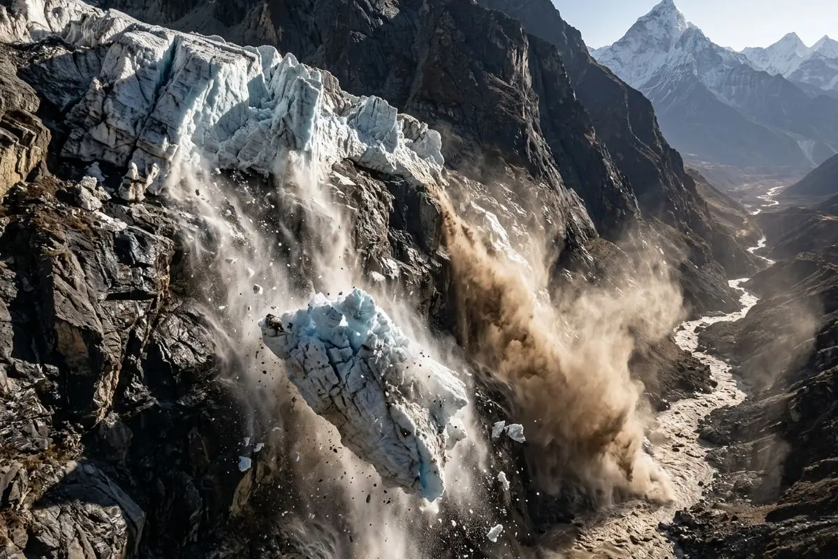
The collapse started on the north face of Langtang Lirung, a 7,234-metre peak in Nepal, at about 5,200 metres. A slab of ice and the bedrock under it dropped about 1,200 metres into the Lhende Khola, which feeds the Bhote Koshi and then the Trishuli. USGS first logged a quake, then said the shaking was the fall itself, a magnitude 5.2 landslide.
The rock that the glacier was sitting on collapsed.
Kristen Cook, geomorphologist, Université Grenoble Alpes
Stephen Hicks, a seismologist at University College London, told The New York Times the mass came out at nearly 400 million metric tons, with energy on the order of 1,000 tons of TNT. Chinese state television said the mudslide from the Nepalese side took six to seven minutes to reach the Gyirong border crossing. There was no cloudburst overhead. Officials in Rasuwa said the sky was clear, which is why the first guess was an earthquake.
THE MORNING THE SLOPE GAVE WAY
- Aug. 26, about 8:30 a.m.: Ice and rock detach on Langtang Lirung’s north face and drop into the Lhende basin.
- Six to seven minutes later: The debris flow hits Gyirong port on the Tibet side of the border.
- The same morning: Material temporarily blocks the Lhende Khola, then the barrier gives way and the surge races into Nepal’s Rasuwa district.
- Aug. 28 to 30: Rescue pauses in bad weather as a new lake formed by the debris starts to overflow into the Lhende Khola and Trishuli.
- Aug. 31: Army teams search the Rasuwagadhi hydropower tunnel and find no one inside, while two remnant lakes remain under watch.
Saswata Sanyal, a disaster-risk specialist, said the Lhende Khola had already flooded twice in 14 months. This time the trigger was an ice-rock avalanche, not a mapped lake bursting its banks.
India’s GLOF Program Covers 195 Lakes
New Delhi is not starting from a blank map. The National Disaster Management Authority has listed 195 glacial lakes as GLOF-vulnerable across Himachal Pradesh, Sikkim, Ladakh, Arunachal Pradesh, Jammu and Kashmir, and Uttarakhand, Hindustan Times reported on Aug. 31, citing the two national agencies that now share the watch.
The Central Water Commission’s monthly glacial lake monitoring reports tracked 902 glacial lakes and water bodies in the Himalayan and Tibetan catchments that drain toward India through the 2024 melt season. Hindustan Times, using CWC’s June 2026 round, put the wider count at 2,843 water bodies larger than 10 hectares, of which 2,485 were glacial lakes; 681 of those lakes sat inside Indian territory, and 147 had grown in water spread that month.
After the Nepal flood, the Centre said it was speeding early-warning work on 188 critical lakes, The Economic Times reported. Himachal Pradesh has flagged 67 vulnerable lakes and asked NDMA for sensors at four of them. Uttarakhand’s disaster secretary, Vinod Kumar Suman, said the state had marked 13 lakes as sensitive. The money behind the national push is modest. NDMA’s National GLOF Risk Mitigation Program set Phase-I at ₹150 crore.
WHAT INDIA IS ACTUALLY COUNTING
| Watch | What it covers | Where it stands |
|---|---|---|
| CWC satellite rounds | Lakes and water bodies from 10 hectares up | 902 sites in the 2024 annual report; a larger 2026 list is still lake-shaped |
| NDMA risk list | GLOF-vulnerable lakes in six states and union territories | 195 lakes, ranked for lake-burst risk |
| NGRMP | Inventory, expeditions, lake sensors, community alerts | ₹150 crore, Phase-I, four Himalayan states |
| Lake weather stations | Temperature, rain, lake level by satellite link | Only three glacial lakes had them, The Wire found |
| C-DAC prototype | LoRa, satellite and 5G lake alerts | Tested at Sissu in Lahaul-Spiti; a Sikkim node sits at Shakho Chho |
A lake list is a real product. It would not have tagged Langtang Lirung’s hanging face, because the failure was the mountainside under the ice, not a reservoir of meltwater held by a moraine. The Wire also noted that hydel projects tend to put sensors about 5 kilometres upstream, and that ITBP and Army posts still work as the manual alarm in the high valleys.
Himansh Tracks Six Glaciers in One Basin
The claim that India has no Himalayan station is already false. NCPOR opened a high-altitude station at Sutri Dhaka on Oct. 9, 2016, at 4,080 metres in Lahaul-Spiti’s Chandra basin. Himansh has two bunk units for eight people and a lab with a steam drill, ground-penetrating radar, GPS, ice corer, flow tracker, radiometer, water-level recorders and an automatic weather station.
From that hut, scientists watch six glaciers covering 280 square kilometres: Sutri Dhaka, Batal, Bara Shigri, Samudra Tapu, Gepang Gath and Kunzum. Two weather stations sit on glacier ice. Five water-level recorders run along 120 kilometres of the Chandra River. NCPOR’s own page says melt supplies 70 to 80 percent of discharge in that basin, against about 44 percent for the Indus as a whole, and that those six glaciers have shown a cumulative negative mass balance.
NCPOR completed a trial winter stay at Himansh in 2024-25 and reported thinner winter snow in the Chandra basin. That is glaciology of a high quality, in one western basin, on foot from a road that opens June to November. It is not a slope-failure net for Langtang, Kedarnath, Sikkim or the hanging ice above Indian dams. The nearest town, Manali, is about 150 kilometres away. The six glaciers under watch sit 1.3 to 63 miles from the huts, Atlas Obscura reported from the field, and some takes a week to reach.
Chamoli Wrote This Script Five Years Ago
The physics is not new on the Indian side of the range. On Feb. 7, 2021, about 27 million cubic metres of rock and glacier ice fell from the north face of Ronti Peak in Chamoli, Uttarakhand. A USGS-linked study in Science described a rock and ice avalanche at Chamoli that turned at once into a debris flow, carried boulders more than 20 metres across, scoured valley walls up to 220 metres above the floor, wrecked two hydropower projects and left more than 200 people dead or missing.
Cook said the Langtang seismic trace looked like Chamoli. Dan Shugar, who led the Chamoli paper, told New Scientist the glacier break might be only part of the Langtang story. South Lhonak in October 2023 was the other family of event, a lake burst that killed dozens in Sikkim and destroyed the 1,200 MW Teesta III plant. NDMA later reinstalled sensors at South Lhonak and upgraded Shako Cho. That is the hazard the ₹150-crore program is built around.
THREE CASCADES, TWO HAZARDS
| Event | Date | Trigger | Human cost | What it hit |
|---|---|---|---|---|
| Chamoli, India | Feb. 7, 2021 | About 27 million m³ of rock and ice off Ronti Peak | More than 200 dead or missing | Two hydropower plants |
| South Lhonak, Sikkim | October 2023 | Glacial lake outburst | Dozens dead downstream | 1,200 MW Teesta III |
| Langtang Lirung, Nepal-Tibet | Aug. 26, 2026 | Hanging rock and ice, USGS magnitude 5.2 | 781 dead in Nepal, 16 in Tibet, as of Aug. 30 | Border port, highway, eight hydropower plants |
Lake sensors would have been the right tool at South Lhonak. They would have been the wrong tool on Ronti Peak and on Langtang Lirung, where the first motion was a steep face letting go. India now has a national lake program and a single-basin mass-balance camp. The hanging-ice problem that has now killed people in Chamoli and in Rasuwa is still the thinner file.
Eight Power Plants Sat in the Debris Path
Congress MP Shashi Tharoor, who flew into Kathmandu the day after the flood, wrote that raging water destroyed at least 19 motorable bridges, washed away roughly 40 kilometres of the Betrawati to Rasuwagadhi highway, and heavily damaged eight operational hydropower projects. He also said large numbers of Indian tourists, including about a hundred on the Kailash Mansarovar yatra, were among those missing.
Chinese Foreign Minister Wang Yi, on an Aug. 29 call with his Nepalese counterpart, called the mudslide their “most severe cross-border disaster” in recent years, CCTV reported. On the Tibet side, 261 foreign nationals from 23 countries were unaccounted for near the border crossing. Ganesh Aryal, chief district officer of Chitwan, told Reuters that Nepal had begun mass burials because bodies were decomposing. “We were left with no other option,” he said.
WHAT THE SURGE TOOK
- Hydropower: Eight plants were heavily damaged, Tharoor said, and on Aug. 31 Nepal Army teams came out of the Rasuwagadhi project tunnel having found no one, with local reports still listing 93 workers untraced.
- The road: About 40 kilometres of highway and at least 19 bridges were gone, which is why helicopters had to do the work that trucks usually do.
- The border: Gyirong port took the first wall of mud; 499 villagers were moved and 555 domestic tourists transferred on the Chinese side, according to accounts circulating with official briefings.
- The pilgrim line: Indian yatra traffic and foreign trekkers were in the same river corridor, which is why missing-person lists run to dozens of nationalities.
- The leftover water: A debris lake formed on the border and began overflowing, which is why rescue kept stopping.
The loud argument online has been climate versus tectonics. Jim Steele and others pointed to Langtang’s 2015 earthquake avalanche and to summer air still below freezing at 5,200 metres. Cook and Shugar have said warming can weaken steep ice even when a single day is not a rainstorm. Either way, a hydropower tunnel and a pilgrim road sat under a hanging face that had no slope alarm, and a school principal in the Trishuli belt moved more than 900 students on a phone warning from Rasuwa. The instrument that worked that morning was a human chain, not a lake gauge.
Why Polar Stations Came First
India’s polar record is real, and it is the comparison a Times of India essay reached for after Langtang. Dakshin Gangotri went up in 1983-84. Maitri opened in 1989. Bharati opened in 2012. Himadri opened in the Arctic in 2008 and shifted to year-round work in 2023. NCPOR director Thamban Meloth told The Indian Express the planned Maitri-II replacement station in Antarctica has an outlay of about ₹2,000 crore over seven years. A parliamentary panel on MoES grants recorded in-principle approval for a polar research vessel with ice-breaking capability at ₹2,329.40 crore.
THE POLAR BILL BESIDE THE LAKE BILL
- Maitri-II: About ₹2,000 crore over seven years to replace a 1989 station that has passed its design life.
- Icebreaker: ₹2,329.40 crore, in-principle, because NCPOR still lacks a dedicated ice-class ship.
- NGRMP Phase-I: ₹150 crore for lake risk work across four Himalayan states.
- Himansh: Three prefabricated units, eight bunks, six glaciers, one basin.
The same March 2026 committee report that blessed Maitri-II also scolded MoES for using only ₹2,826.83 crore of a ₹3,658.08 crore 2025-26 budget by Jan. 31, and for getting 86.67 percent of what it asked for in 2026-27. Under Mission Mausam, the panel pushed a cloud-physics lab at IITM Pune and special gear in cloudburst country, including the western Himalaya. Polar science and a Himalayan lake program can run together. They are not the same job as watching hanging ice and thawing rock above inhabited valleys.
An Economic Times essay in February put a permanent Himalayan research station at ₹5,000 to ₹7,000 crore and counted 10 Doppler radars along a 2,500-kilometre mountain arc. Those radars see rain. Langtang produced almost none. The gap is not only money. It is which failure mode the gear is bought to see.
Six Minutes Is the Warning Window
Chinese television’s 6 to 7 minutes from the slope to Gyirong is the whole operational fact. A lake gauge on a different mountain would not have shortened that clock. A geophone, a camera on the north face, and a siren in Rasuwa and Gyirong might have. C-DAC’s Sissu prototype already sends lake data by LoRa, satellite and 5G. NDMA member Krishna Vatsa told Hindustan Times the Himachal test was at lower height and that Sikkim’s higher lakes are next. Higher still is the hanging ice that does not sit in a lake at all.
The U.S. Embassy in Kathmandu said on Aug. 30 that two lakes remain upstream of the flood zone. One has been draining. A second, larger lake is still under assessment, and downstream flood risk lasts until both are gone. Nepal’s hydrology office has flagged heavy rain in Bagmati’s hills through Sept. 1.
https://x.com/USEmbassyNepal/status/2094000748891926993
India can keep Maitri, Bharati and Himadri, and it can keep expanding the 195-lake list. The Langtang scar is a reminder that the next inland surge on the Indian side is as likely to start as Chamoli did, on a steep face above a river that already has a powerhouse and a road in it. As of Monday, the larger remnant lake was still being watched, and the rain forecast for the hills had not been lifted.

-
 TECH1 year ago
Where Garmin Watches are Made and How They are Assembled
-

 AUTO3 months ago
Tesla’s Roadster Is ‘a Few Weeks Away,’ Says Its Chief Designer
-
 NEWS10 years ago
Samsung Releases Galaxy Note7 TV Ad as Reddit AMA Leaks Specs
-
 NEWS10 years ago
Android 7.0 Nougat Rolls Out To Nexus Devices With New Emoji, Features
-
 FINANCE9 years ago
Cardano Price Surges as ADA Enters the Crypto Top Ten List
-
 NEWS10 years ago
Pre-Order the First Camera Made for Facebook Live Streaming Video
-
 FINANCE1 year ago
Binance Suspends Trading and Withdrawals for a System Upgrade
-
 FINANCE9 years ago
RChain Price Jumps Nearly 150% to a New All-Time High of $2.03