
NEWS
Cyclone Arnab Hits Andhra After a Delayed Quiet Season
Cyclone Arnab, 2026’s first named North Indian Ocean storm, hit Andhra as a very severe cyclone even as a strong El Niño usually quiets the Bay of Bengal.

Cyclone Arnab hit the Andhra Pradesh and Yanam coast on October 28 as a very severe cyclonic storm. It was the first named storm of the 2026 North Indian Ocean season, and it arrived in the middle of a strengthening El Niño. Researchers have long tied El Niño years to fewer, weaker Bay of Bengal cyclones. This one still came in with landfall winds of 125 to 135 kmph, gusting to 150 kmph.
Arnab Came Ashore Between Narsapur and Yanam
The India Meteorological Department said the centre crossed southwest of Yanam near 16.45°N, 81.9°E. That put it about 20 km east-northeast of Narsapur, 40 km southwest of Yanam, and 60 km southwest of Kakinada. The landfall window ran from 2 a.m. to 8 a.m. India Standard Time on October 28. Yanam is a small coastal enclave of Puducherry sitting on the Andhra shore.
IMD bulletin 18, issued after noon that day, still listed the 125 to 135 kmph landfall winds and a surge of 0.5 to 1.0 m above the astronomical tide. By 12:30 p.m. IST the centre lay over the Andhra Pradesh and Yanam coasts near 16.7°N, 81.8°E, and the storm had already been cut to a severe cyclonic storm at 95 to 105 kmph, gusting to 115 kmph. The department said it would weaken further into a cyclonic storm within about three hours and into a deep depression after that.
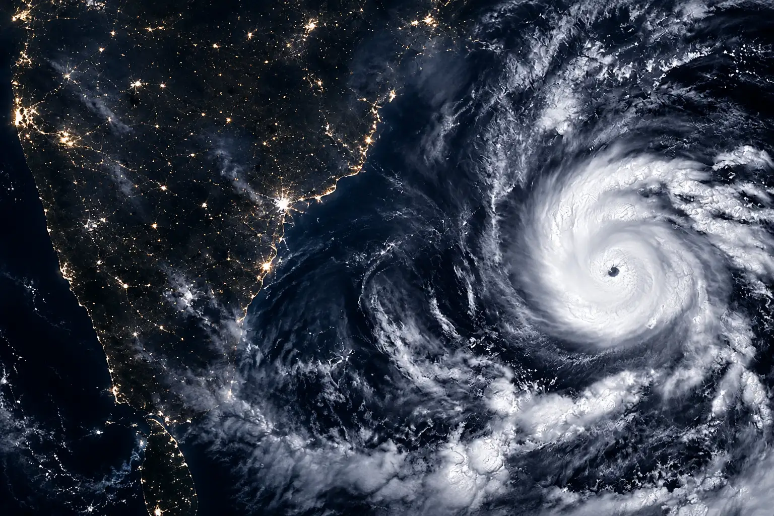
Two nights earlier, the VIIRS instrument on NOAA-20 had photographed the system at 20:12 UTC on October 26, which is 1:42 a.m. IST on October 27. NASA Earth Observatory, in an Image of the Day filed by Adam Voiland with a VIIRS night composite by Michala Garrison, put sustained winds then at about 140 km/h (85 mph), citing IMD. On October 27, while the storm was still over the west-central Bay, IMD Director General Mrutyunjay Mohapatra said it held 140 to 150 kmph, with gusts to 165 kmph.
HOW ARNAB BUILT
- October 25, 2026: Emerges in the Bay of Bengal as the basin’s first named storm of the year, a late start against the usual April or May opening.
- October 26, 2026: NOAA-20 VIIRS records the night-time disc at 20:12 UTC, with IMD winds near 140 km/h.
- October 27, 2026: Mohapatra places the very severe cyclonic storm about 240 km east-southeast of Kakinada, still packing 140 to 150 kmph over water.
- October 28, 2026: Crosses the Andhra Pradesh and Yanam coasts between 2 a.m. and 8 a.m. IST as a very severe cyclonic storm, then weakens over land by early afternoon.
The name Arnab, pronounced Or-nab, came from Bangladesh’s slot on the regional naming list. Next on that list is Murasu, from India.
What a Very Severe Cyclonic Storm Means
IMD calls a storm “very severe” when three-minute sustained winds sit between 118 and 166 kmph. Arnab’s landfall band, 125 to 135 kmph with gusts to 150 kmph, sat in the lower half of that class. NASA compared that strength to Category 1 on the Saffir-Simpson hurricane wind scale, whose Category 1 band is 74 to 95 mph on a one-minute average. Converted, 125 to 135 kmph is about 78 to 84 mph, so the comparison holds even though the two agencies average wind over different intervals.
IMD INTENSITY LADDER
| Class | Sustained wind (kmph) | Where Arnab sat |
|---|---|---|
| Cyclonic storm | 62 to 87 | Named stage on October 26 |
| Severe cyclonic storm | 88 to 117 | Over land by 12:30 p.m. IST on October 28 |
| Very severe cyclonic storm | 118 to 166 | Landfall, 125 to 135 gusting 150 |
| Extremely severe cyclonic storm | 167 to 221 | Not reached |
| Super cyclonic storm | 222 and above | Not reached |
For Andhra Pradesh the class is not rare in the long record, but it had been quiet. IMD files on storms that hit the state between 1970 and 2023 list 10 very severe cyclonic storms. Arnab is the 11th. The last one to affect the state was Titli in October 2018, eight years earlier.
El Niño Usually Cuts Bay of Bengal Storms
The Climate Prediction Center at NOAA, in its diagnostic discussion dated 8 October 2026, had the Pacific well into a strong-to-very strong El Niño advisory. Niño-3.4 stood at +2.1°C, Niño-3 at +3.0°C, and Niño-1+2 at +3.9°C. Patches of the eastern equatorial Pacific ran more than +4.0°C above the 1991-2020 mean. CPC put an 83% chance on an October-December event that would beat any El Niño since 1950 on a three-month relative Niño index of +2.5°C or more, and it kept a greater than 83% chance of a strong-to-very strong event through January-March 2027.
El Niño continues to strengthen, with a strong-to-very strong El Niño likely through January-March 2027 (remaining greater than an 83% chance).
Climate Prediction Center, ENSO Diagnostic Discussion, 8 October 2026
That is the climate backdrop NASA flagged when it published the night image. Pankaj Bhardwaj, Dushmanta R. Pattanaik, and Omvir Singh, writing in the International Journal of Climatology in 2019, tracked post-monsoon (October-December) Bay of Bengal cyclone activity from 1972 to 2015. Frequency, accumulated cyclone energy, and power dissipation all moved opposite Niño-3.4, at 95% confidence. La Niña years were stormier and stronger. Mean ACE and PDI were about twice as high as in El Niño years. Mean tropical-cyclone days ran 7.64 in La Niña years and 3.68 in El Niño years.
POST-MONSOON BAY OF BENGAL, 1972 TO 2015
| Metric | El Niño years | La Niña years |
|---|---|---|
| Years in the sample | 15 | 14 |
| Named storms in the peak season | 23 | 35 |
| Mean storms per year | 1.53 | 2.50 |
| Share of the 92-storm peak-season total | 25% | 38% |
| Mean tropical-cyclone days per year | 3.68 | 7.64 |
| ACE and PDI | About half of La Niña | About twice El Niño |
El Niño does not shut the Bay. It thins the odds and trims the energy. A mean of 1.53 named storms a year still leaves room for a landfalling very severe cyclone. Mohapatra has also said that in El Niño years North Indian Ocean cyclones tend to form closer to the equator, which steers them toward Andhra Pradesh and Tamil Nadu more than toward Odisha and West Bengal. The quiet-season pattern, in other words, still aims the storms that do form at a densely settled stretch of the Godavari-Krishna coast.
84,396 People Were Already in Shelters
Andhra Pradesh Chief Minister N. Chandrababu Naidu said 290 cyclone shelters were standing and 84,396 people had been moved into them. More than 30,000 fishing boats had been called back from the sea, and 93 Andhra boats and their crews were reported safe at Gopalpur in Odisha. About 5,000 pregnant women had been shifted to health centres and hospitals, and 1,316 ambulances were on standby. Schools in the affected districts stayed closed on October 28. Flights that day were cancelled. South Coast Railway cancelled 57 trains and rescheduled 15.
National Disaster Response Force Inspector General N.S. Bundela said Andhra Pradesh took the worst of the rain, with 764 villages affected. Thirty-nine NDRF teams were in the field across Andhra Pradesh, Odisha, and neighbouring states, four of them airlifted. In a letter to Union Home Minister Amit Shah, Naidu put the early property tally at 180 houses destroyed and 220 trees down, with power cut in several areas. Konaseema, Kakinada, and the Godavari districts sat in the core wind field.
Three people died in Andhra Pradesh. None of the three was killed by the surge. Two died on live wires after the wind had already snapped the lines, and one died under a tree.
THE THREE CONFIRMED DEATHS
- The tree: Chokka Kishore Kumar, 46, died around 12:30 a.m. on October 28 after a tree fell on him in Bhimavaram, West Godavari district; he was declared dead on arrival at hospital.
- The field wire: A 53-year-old man died on the night of October 27 in Visakhapatnam district after touching a live wire that had snapped over an agricultural field channel.
- The house wire: A 55-year-old woman died on the morning of October 28 after stepping on an exposed live wire outside her home in Yellamanchili town, Anakapalli district.
Bundela told reporters the rescue push had already moved pregnant women to hospitals and had put women, children, and older people first in the low-lying belts. Thirty-eight people were taken out of Yanam on the night before landfall. The deaths that did occur were the kind that arrive after the eyewall has passed, when a wet road and a live cable are still in the dark.
A Season That Skipped April and May
The North Indian Ocean does not run one long Atlantic-style season. It has two peaks, a pre-monsoon pulse in April and May and a stronger post-monsoon pulse from October to December, with the southwest monsoon’s wind shear usually suppressing storms in between. NASA called Arnab a late start for a basin that typically produces named cyclones in April or May, pointing readers to Colorado State University’s North Indian Ocean season climatology.
That late opening is the other half of the El Niño irony. The pre-monsoon window produced no named storm at all. The first name of 2026 then arrived in the post-monsoon peak, on a coast that has seen this class of storm before, and it still reached the very severe rung. CSU’s historical file, built from Joint Typhoon Warning Center tracks in IBTrACS, shows how thin some recent North Indian years have been on energy: 2024 finished with four named storms and an ACE of 8, and 2025 with five named storms and an ACE of 9.1. A delayed first name does not, by itself, mean a harmless year. It means the calendar’s first punch can land in October, on rice land and fishing harbours, instead of in May.
Rain Stations Logged 26 cm Before Noon
By 8:30 a.m. IST on October 28, IMD had already banked extremely heavy rain across north coastal Andhra. The highest official mark in that bulletin was 26 cm at Garividi in Vizianagaram district. Several other stations in the same belt were close behind, and the department kept a moderate-to-high flash flood risk up through 11:30 a.m. IST on October 29 for watersheds from Guntur and Krishna through Visakhapatnam, Vizianagaram, and Srikakulam, plus belts of Odisha, Telangana, and Chhattisgarh.
SELECTED TOTALS TO 8:30 A.M. IST, OCTOBER 28
| Station | District | Rain (cm) |
|---|---|---|
| Garividi | Vizianagaram | 26 |
| Anakapalle | Anakapalli | 25 |
| Srungavarapukota | Vizianagaram | 25 |
| Vepada | Vizianagaram | 25 |
| Cheepurupalle | Vizianagaram | 25 |
| Bheemunipatnam | Visakhapatnam | 24 |
| Yelamanchili | Anakapalli | 24 |
| Visakhapatnam | Visakhapatnam | 22 |
Odisha’s observed marks in the same bulletin were lower, with Mohana in Gajapati at 17 cm and Ganjam at 15 cm, but the flash-flood map still covered Ganjam, Gajapati, Koraput, and a long list of interior districts. A day after the Andhra landfall, that inland water was the part of the storm that had not yet finished. The eyewall had already been downgraded over land. The watersheds had not.
Arnab will be logged as a late, landfalling very severe cyclonic storm in a Pacific El Niño that CPC still expected to strengthen into winter. The Bay of Bengal’s El Niño file said that combination should have been quieter. On the Godavari coast it was still enough to pull 84,396 people into shelters, kill three on trees and wires, and leave flash-flood watches running into October 29.

ADNOC Ship Hit in Hormuz Leaves One Crew Missing

SpiceJet’s Rs 5,500 Crore Plan Follows a Rescue That Failed

Hasina’s Return Fight Sets Fire to Yunus’s Bank

Bancroft Recants the 2018 Inquiry and Names the Team

Adhikari Ties the Saffron Saree Row to School Licences

Clancy Juror Says the Holdout Never Cited Evidence

The iPhone 18 Pro Max Splits Apple’s Fall in Two

OpenAI Calls GPT-6 Astra AGI Then Locks Its Exploits

Trump Claims Hormuz Control as Oil Holds Near $96

Russia Closes the Goethe-Institut Berlin Tried to Save

 NEWS2 months ago
Clancy Juror Says the Holdout Never Cited Evidence
- NEWS3 months ago
The iPhone 18 Pro Max Splits Apple’s Fall in Two
- NEWS3 months ago
OpenAI Calls GPT-6 Astra AGI Then Locks Its Exploits
- BUSINESS3 months ago
Trump Claims Hormuz Control as Oil Holds Near $96
- LIFESTYLE3 months ago
Russia Closes the Goethe-Institut Berlin Tried to Save
- AUTO3 months ago
Volkswagen’s Job Cuts Leave Four Plants Without Cars
- NEWS3 months ago
Dyson Puts Nurovi Robots on Sale Without the UV Flagship
- BUSINESS2 months ago
US Destroys Five Iranian Tankers as the Shock Hits Jordan